
Is Geospatial Technologies right for you?
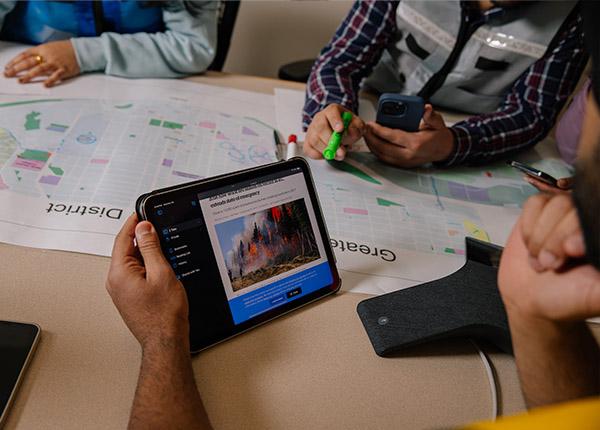
Geospatial tools—like maps, dashboards, and spatial data—are essential for understanding what’s happening during an emergency.
This micro-credential program helps non-technical professionals turn those tools into practical, real-world skills. You’ll learn how to gather, validate, and apply geospatial information to support evidence-informed decision-making in public safety and emergency management.
By focusing on accessible, easy-to-use technologies, the program ensures you can confidently apply your new skills to planning, response, and recovery efforts across a range of sectors.
Geospatial technologies help professionals make better, faster decisions by showing how data connects to real places. Geospatial tools are applied in diverse fields, helping professionals map emergencies, design safer communities, track environmental change, and strengthen public health initiatives.
Through this program, learners gain practical skills to collect, analyze, and apply spatial data in their work. Graduates are prepared to use mapping and visualization tools to enhance emergency planning, response, and recovery — and to support stronger, more resilient communities across government, Indigenous communities, and private sector organizations.
| Sector/Field | Position Examples | Applicability |
|---|---|---|
| Emergency Management & Public Safety | Emergency Manager, Public Safety Officer, Program Coordinator, Risk Analyst, EOC Operations Chief, First Responder | Supports real-time mapping, situational awareness, and coordinated emergency response. |
| First Nations & Government | Emergency Planner, Community GIS Liaison, Land Registry Technician, Policy or Planning Analyst | Enables data-driven land use planning, emergency coordination, and integration of traditional and local knowledge. |
| Health & Social Services | Public Health Analyst, Social Impact Planner, Environmental Health Officer | Uses spatial data to map disease outbreaks, social determinants, and vulnerable populations for equitable service delivery. |
| Infrastructure, Utilities & Resource Sector (Public & Private) | Geomatics Specialist, Asset Management Officer, Environmental Risk Analyst, Critical Infrastructure Coordinator | Private and public organizations use GIS to manage energy grids, transportation, and natural resources, improving efficiency, safety, and sustainability. |
| Environmental & Resource Management | Natural Resource Planner, Field Data Technician, Forest Resource Mapping Specialist | Tracks land, water, and forest resources to support sustainable development and climate adaptation. |
| Insurance & Risk Management | GIS Risk Technician, Portfolio Risk Analyst, Chief Geospatial Risk Officer | Maps hazards like floods and wildfires to assess exposure, inform pricing, and improve loss prevention. |
| NGOs & Community Services | Humanitarian GIS Coordinator, Disaster Response Mapper, Community Resilience Officer | Supports disaster response, humanitarian logistics, and community resilience through mapping and spatial analysis. |
Designed with practical learning and real-world relevance in mind, the program’s key strengths include:
Focused on real-world applications for emergency management and public safety
Hands-on experience using ArcGIS Online (includes one-year license)
Designed for non-technical professionals—no prior GIS training required
Learn from experienced instructors working in the field
Develop practical skills you can apply immediately in your role
A flexible learning option from Canada’s leading public safety educator
No prior technical GIS experience is needed—this program introduces geospatial tools in a clear, practical way that helps non-specialists apply mapping and situational awareness technologies in their work.
The Micro-certificate in Geospatial Technologies provides the foundational knowledge and skills to interpret, validate, and apply geospatial data in emergency management settings. Using ArcGIS Online, you’ll create maps, dashboards, and situational briefings that support decision-making.
By the end of the program, you will be able to:
Explain how geospatial data supports situational awareness and emergency planning
Identify and use public, commercial, and custom data sources
Perform basic data gathering, validation, and management
Incorporate Indigenous perspectives and ethical considerations into datasets
Apply practical technologies to collect and visualize data
Communicate geospatial findings clearly in reports and Emergency Operations Centre (EOC) briefings
The Micro-certificate in Geospatial Technologies includes three sequential, co-requisite online courses, each worth one credit.
Courses are instructor-led and designed to keep learners engaged through weekly deadlines, interactive discussions, and hands-on mapping activities. You’ll complete readings, assignments, and applied projects using real data and tools. Each course requires about 14 hours of learning time.
You can complete the entire program in just a few months. View the 2026 - 2027 training schedule. Courses in the program are co-requisites, therefore, students register for all three courses at the same time and must complete them in sequential order.
Courses include:
EMRG-1542 Managing Spatial Data (1 credit)
EMRG-1544 Geospatial Analysis for Planning and Response (1 credit)
Tuition includes a one-year ArcGIS Online Student Use license, and graduates earn both a micro-certificate and a digital badge.
Due to the technical and applied nature of this program—particularly when working with ArcGIS and related geospatial tools—students are expected to have foundational computer skills, including the ability to take and save screenshots, copy and paste URLs, download and upload files, and export tabular data (e.g., saving tables as CSV files).
Access to at least two computer screens is strongly recommended, as a dual-screen setup allows learners to view instructional materials while simultaneously working within software platforms. This configuration significantly improves navigation efficiency and supports successful completion of hands-on course activities.
Minimum Technical Requirements
Students must be able to:
- Download, save, rename, locate, and upload files
- Create and organize folders on their computer
- Take and save screenshots (PNG or JPG)
- Copy and paste URLs accurately
- Open and navigate multiple browser tabs
- Follow multi-step technical instructions independently
- Open and save spreadsheet (CSV) files in MS Excel, Google Sheets, Apple Numbers or similar program
- Understand basic table structure (rows, columns, fields)
Students must have access to:
- A desktop or laptop computer, and a MS windows, Apple iOS or Google Android mobile device
- Reliable high-speed internet
- An up-to-date web browser (Chrome, Edge, or Firefox recommended)
- Two computer screens or a dual‑monitor setup to allow simultaneous viewing of instructional materials and GIS software.
EMRG-1540 Fundamentals of Geospatial Technology: $800 + $12.52 LSF + SSF $6.00
EMRG-1542 Managing Spatial Data: $800 + $12.52 LSF + SSF $6.00
EMRG-1544 Geospatial Analysis for Planning and Response: $800 + $12.52 LSF + SSF $6.00
Total program cost: approximately $2,400
LSF - learner services fee
SSF - Student Supports Fee
All course materials and the ArcGIS license are included in tuition.
Applicants must be at least 18 years old.
Apply through EducationPlannerBC by completing the program application form.
Once accepted, you’ll register for all three courses at the same time. Courses must be completed in sequence.
Self-assessment
Before starting the program, it’s strongly recommended that learners complete the free pre-assessment on:
Incident Command System (ICS) concepts
Emergency Operations Centre (EOC) concepts
This helps ensure you’re familiar with key emergency management terminology.
Q. Will I get access to GIS software?
Yes. Tuition includes a one-year ArcGIS Online Student Use license, provided through JIBC. All students must use the license issued by the program.
Q. Do I need prior GIS training to succeed in this program?
No. This program is designed for learners with little or no GIS experience. You’ll develop practical, easy-to-apply skills for real-world emergency management.
Q. How long do I have to complete the program?
You’ll have up to 12 months to finish all three courses, but it’s recommended that you take them back-to-back within three months to stay current with evolving technology and maintain momentum.